Tuesday, February 28, 2012

CONTINENT


Continent

From Wikipedia, the free encyclopedia
Animated, color-coded map showing various continents and regions. Depending on the convention and model, some continents may be consolidated or subdivided: for example,Eurasia is often subdivided into Europe and Asia (red shades), while North and South America are sometimes recognized as one American continent (green shades).
A continent is one of several very large landmasses on Earth. They are generally identified by convention rather than any strict criteria, with seven regions commonly regarded as continents—they are (from largest in size to smallest): AsiaAfricaNorth AmericaSouth America,AntarcticaEurope, and Australia.[1]
Plate tectonics is the geological process and study of the movement, collision and division of continents, earlier known as continental drift.
Residents of Britain and Ireland sometimes refer to Continental Europe, that is, the mainland of Europe, excluding the British Isles,[2] Icelandand some other islands, as "the Continent".

CONTINENT


Continent

From Wikipedia, the free encyclopedia

Animated, color-coded map showing various continents and regions. Depending on the convention and model, some continents may be consolidated or subdivided: for example,Eurasia is often subdivided into Europe and Asia (red shades), while North and South America are sometimes recognized as one American continent (green shades).
A continent is one of several very large landmasses on Earth. They are generally identified by convention rather than any strict criteria, with seven regions commonly regarded as continents—they are (from largest in size to smallest): AsiaAfricaNorth AmericaSouth America,AntarcticaEurope, and Australia.[1]
Plate tectonics is the geological process and study of the movement, collision and division of continents, earlier known as continental drift.
Residents of Britain and Ireland sometimes refer to Continental Europe, that is, the mainland of Europe, excluding the British Isles,[2] Icelandand some other islands, as "the Continent".

Friday, February 24, 2012

HOW TO USE COMPASS


Using a compass

Turning the compass scale on the map (D - the local magnetic declination)
When the needle is aligned with and superimposed over the outlined orienting arrow on the bottom of the capsule, the degree figure on the compass ring at the direction-of-travel (DOT) indicator gives the magnetic bearing to the target (mountain).
A magnetic compass points to magnetic north pole, which is approximately 1,000 miles from the true geographic North Pole. A magnetic compass's user can determine true North by finding the magnetic north and then correcting for variation and deviation. Variation is defined as the angle between the direction of true (geographic) north and the direction of the meridian between the magnetic poles. Variation values for most of the oceans had been calculated and published by 1914.[81] Deviation refers to the response of the compass to local magnetic fields caused by the presence of iron and electric currents; one can partly compensate for these by careful location of the compass and the placement of compensating magnets under the compass itself. Mariners have long known that these measures do not completely cancel deviation; hence, they performed an additional step by measuring the compass bearing of a landmark with a known magnetic bearing. They then pointed their ship to the next compass point and measured again, graphing their results. In this way, correction tables could be created, which would be consulted when compasses were used when traveling in those locations.
Mariners are concerned about very accurate measurements; however, casual users need not be concerned with differences between magnetic and true North. Except in areas of extreme magnetic declination variance (20 degrees or more), this is enough to protect from walking in a substantially different direction than expected over short distances, provided the terrain is fairly flat and visibility is not impaired. By carefully recording distances (time or paces) and magnetic bearings traveled, one can plot a course and return to one's starting point using the compass alone.[74]
Soldier using a prismatic compass to get an azimuth.
Compass navigation in conjunction with a map (terrain association) requires a different method. To take a map bearing or true bearing (a bearing taken in reference to true, not magnetic north) to a destination with a protractor compass, the edge of the compass is placed on the map so that it connects the current location with the desired destination (some sources recommend physically drawing a line). The orienting lines in the base of the compass dial are then rotated to align with actual or true north by aligning them with a marked line of longitude (or the vertical margin of the map), ignoring the compass needle entirely.[74] The resulting true bearing or map bearing may then be read at the degree indicator or direction-of-travel (DOT) line, which may be followed as an azimuth(course) to the destination. If a magnetic north bearing or compass bearing is desired, the compass must be adjusted by the amount of magnetic declination before using the bearing so that both map and compass are in agreement.[74] In the given example, the large mountain in the second photo was selected as the target destination on the map. Some compasses allow the scale to be adjusted to compensate for the local magnetic declination; if adjusted correctly, the compass will give the true bearing instead of the magnetic bearing.
The modern hand-held protractor compass always has an additional direction-of-travel (DOT) arrow or indicator inscribed on the baseplate. To check one's progress along a course or azimuth, or to ensure that the object in view is indeed the destination, a new compass reading may be taken to the target if visible (here, the large mountain). After pointing the DOT arrow on the baseplate at the target, the compass is oriented so that the needle is superimposed over the orienting arrow in the capsule. The resulting bearing indicated is the magnetic bearing to the target. Again, if one is using "true" or map bearings, and the compass does not have preset, pre-adjusted declination, one must additionally add or subtract magnetic declination to convert the magnetic bearing into atrue bearing. The exact value of the magnetic declination is place-dependent and varies over time, though declination is frequently given on the map itself or obtainable on-line from various sites. If the hiker has been following the correct path, the compass' corrected (true) indicated bearing should closely correspond to the true bearing previously obtained from the map.
Compasses are to be laid down on a leveled surface so the needle could point to the magnetic north more accurately, as to that the needle only rests or hangs on a bearing fused to the compass casing , if used at a tilt , the needle might hit the casing on the compass , and hence , not move. This will give a faulty reading . To see if the needle is well leveled , look closely at the needle , and tilt it slightly to see if the needle is swaying side to side freely and the needle not contacting the casing of the compass. If the needle tilts to one direction , tilt the compass slightly and gently to the opposing direction until the compass needle is horizontal , lengthwise. Items to avoid around compasses are magnets of any kind and any electronics. Magnetic fields from electronics can easily disrupt the needle , avoiding it from pointing with the earth's magnetic fields, causing interference. The earth's natural magnetic forces are considerably weak , measuring at 0.5 Gauss and magnetic fields from household electronics can easily exceed it , overpowering the compass needle. Exposure to strong magnets , or magnetic interference can sometimes cause the magnetic poles of the compass needle to differ or even reverse. Avoid iron rich deposits when using a compass , for example , certain rocks which contain magnetic minerals , like Magnetite.This is often indicated by a rock with a surface which is dark and has a metallic luster, not all magnetic mineral bearing rocks have this indication. To see if a rock or an area is causing interference on a compass , get out of the area , and see if the needle on the compass moves. If it does , it means that the area or rock the compass was previously at/on is causing interference and should be avoided.

MODERN COMPASSES


Modern compasses


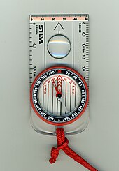
A liquid-filled compass with a lanyard for the neck
Modern compasses usually use a magnetized needle or dial inside a capsule completely filled with fluid (oil, kerosene, or alcohol is common). While older designs commonly incorporated a flexible diaphragm or airspace inside the capsule to allow for volume changes caused by temperature or altitude, modern liquid compasses utilize smaller housings and/or flexible materials for the capsule itself to accomplish the same result. The fluid dampens the movement of the needle and causes the needle to stabilize quickly rather than oscillate back and forth around magnetic north. North on the needle or dial, as well as other key points are often marked withphosphorescentphotoluminescent, or self-luminous materials[73] to enable the compass to be read at night or in poor light.
Many modern recreational and military compasses integrate a protractor with the compass, using a separate magnetized needle. In this design the rotating capsule containing the needle has a transparent base containing map orienting lines as well as an orienting 'box' or outline for the needle.[74] The capsule is then mounted in a transparent baseplate containing a direction-of-travel (DOT) indicator for use in taking bearings directly from a map.[74]

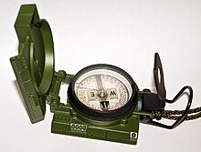
Liquid filled lensatic compass

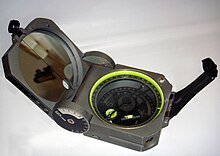
Cammenga air filled lensatic compass
Other features found on some modern compasses are map and romer scales for measuring distances and plotting positions on maps, luminous markings on the face or bezels, various sighting mechanisms (mirror, prism, etc.) for taking bearings of distant objects with greater precision, "global" needles for use in differing hemispheres, adjustable declination for obtaining instant true bearings without resort to arithmetic, and devices such as inclinometers for measuring gradients.[74]
The military forces of a few nations, notably the United States Army, continue to utilize lensatic field compasses with magnetized compass dials or cards instead of needles. A lensatic-card compass permits reading the bearing off the compass card with only a slight downward glance from the sights (see photo), but may require a separate protractor for use with a map.[74][75] The official U.S. military lensatic compass does not use fluid to damp needle swing, but ratherelectromagnetic induction to damp the needle. A "deep-well" design is used to allow the compass to be used globally with little or no effect in accuracy caused by a tilting compass dial. As induction forces provide less damping than fluid-filled designs, a needle lock is fitted to the compass to reduce wear, operated by the folding action of the rear sight/lens holder. The use of air-filled induction compasses has declined over the years, as they may become inoperative or inaccurate in freezing temperatures or humid environments.[76]
Some military compasses, like the U.S. SandY-183 (name derived from Stocker & Yale) military lensatic compass, the Silva 4b Militaire, and the Suunto M-5N(T) contain the radioactive material tritium (3H) and a combination of phosphors.[77] The U.S. military compass, made by Stocker & Yale (later, Cammenga) contained 120 mCi (millicuries) of tritium. The purpose of the tritium and phosphors is to provide illumination for the compass, via radioluminescent tritium illumination, which does not require the compass to be "recharged" by sunlight or artificial light.[78]
Mariner's compasses can have two or more magnetic needles permanently attached to a compass card. These move freely on a pivot. A lubber line, which can be a marking on the compass bowl or a small fixed needle indicates the ship's heading on the compass card. Traditionally the card is divided into thirty-two points (known as rhumbs), although modern compasses are marked in degrees rather than cardinal points. The glass-covered box (or bowl) contains a suspended gimbal within a binnacle. This preserves the horizontal position.

[edit]Thumb compass


Thumb compass on left
A thumb compass is a type of compass commonly used in orienteering, a sport in which map reading and terrain association are paramount. Consequently, most thumb compasses have minimal or no degree markings at all, and are normally used only to orient the map to magnetic north. Thumb compasses are also often transparent so that an orienteer can hold a map in the hand with the compass and see the map through the compass.

[edit]Gyrocompass

A gyrocompass is similar to a gyroscope. It is a non-magnetic compass that finds true north by using an (electrically powered) fast-spinning wheel and friction forces in order to exploit the rotation of the Earth. Gyrocompasses are widely used on ships. They have two main advantages over magnetic compasses:
  • they find true north, i.e., the direction of Earth's rotational axis, as opposed to magnetic north,
  • they are not affected by ferromagnetic metal (including iron, steel, cobalt, nickel, and various alloys) in a ship's hull. (No compass is affected by nonferromagnetic metal, although a magnetic compass will be affected by any kind of wires with electric current passing through them.)
Large ships typically rely on a gyrocompass, using the magnetic compass only as a backup. Increasingly, electronic fluxgate compasses are used on smaller vessels. However compasses are still widely in use as they can be small, use simple reliable technology, are comparatively cheap, often easier to use than GPS, require no energy supply, and unlike GPS, are not affected by objects, e.g. trees, that can block the reception of electronic signals.

[edit]Solid state compasses

Small compasses found in clocks, mobile phones, and other electronic devices are solid-state compasses, usually built out of two or three magnetic field sensors that provide data for a microprocessor. The correct heading relative to the compass is calculated using trigonometry.
Often, the device is a discrete component which outputs either a digital or analog signal proportional to its orientation. This signal is interpreted by a controller or microprocessor and used either internally, or sent to a display unit. The sensor uses highly calibrated internal electronics to measure the response of the device to the Earth's magnetic field.
GPS receivers using two or more antennae can now achieve 0.5° in heading accuracy (e.g.[79]) and have startup times in seconds rather than hours for gyrocompass systems. Manufactured primarily for maritime applications, they can also detect pitch and roll of ships.

[edit]Specialty compasses


A standard Brunton Geo, used commonly by geologists
Apart from navigational compases, other specialty compasses have also been designed to accommodate specific uses. These include:
  • Qibla compass, which is used by Muslims to show the direction to Mecca for prayers.
  • Optical or prismatic hand-bearing compass, most often used by surveyors, but also by cave explorers, foresters, and geologists. This compasses ordinarily uses a liquid-damped capsule[80] and magnetized floating compass dial with an integral optical (direct or lensatic) or prismatic sight, often fitted with built-in photoluminescent or battery-powered illumination.[74] Using the optical or prism sight, such compasses can be read with extreme accuracy when taking bearings to an object, often to fractions of a degree. Most of these compasses are designed for heavy-duty use, with high-quality needles and jeweled bearings, and many are fitted for tripod mounting for additional accuracy.[74]
  • Trough compasses, mounted in a rectangular box whose length was often several times its width, date back several centuries. They were used for land surveying, particularly with plane tables.